Croatia Ferry Maps
Maps of Ferries in Croatia:
On this page, you will find current ferry maps for the whole of Croatia. It includes international ferry lines from Italy and local ferry lines that are split into 3 sections, each one for North, Central and South Croatian Islands.
Italy to Croatia ferry map:
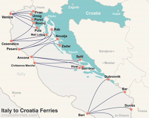
Italy to Croatia ferries – a map of ferries from Italy to Croatia – this is the map of all ferries that are sailing from Italy to Croatia.
Venice to Croatia ferry map:

Venice (Italy) to Croatia (Istria) ferries – a map of ferries from Italy to Istria – this is the map of all ferries that are sailing from Venice as well as from Trieste to Istrian ferry ports. If you are visiting Istria or Venice, this is a very good map to check what are your options.
Croatia Islands ferry maps:
North Adriatic islands – Kvarner Archipelago:
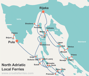
North Adriatic Local Ferries – a map of ferries to North Adriatic area – this is a map that shows all ferry lines in the north coast of Croatia (Adriatic coast) including Kvarner islands. If you are visiting Pula or Rijeka and plan to do some island hopping in the area, this is the right map to have.
North Dalmatian Islands – Zadar Archipelago:
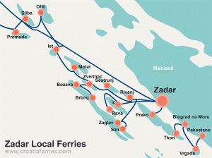
Zadar Islands Local Ferry Map – this map show all ferries to Zadar islands. If you are visiting Zadar and plan some island hopping from there, this is a very good map to have.
Central Dalmatian Islands – Sibenik Archipelago:

Šibenik Islands Local Ferry Map – Sibenik islands and archipelago ferry map that shows all ferry lines in the area. Good to have if you are visiting Zadar or Split and planning to visit Sibenik islands. Also good if you plan to visit Krka National Park, as some of these ferries are departing to the islands very close to the Park.
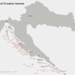
South Dalmatian Islands – Split & Dubrovnik Archipelago:

Dubrovnik, Split and Dalmatian Islands local ferry map – this is our most popular map. It shows all ferry routes connecting Dalmatian islands between Split and Dubrovnik. An essential map if you plan to visit any of these islands especially if your plan is to island hop in the area. On our island hopping page, you can find links to articles about how to plan your island hopping holiday in the area.
Interactive map of all ferry ports in Croatia and Italy

Map of all ferries in and to Croatia – this is a map of all ferry ports in Croatia and all places in Italy from where there are ferry connections to Croatia. This is a Google / Open Street map, good to check other locations in regards to a particular ferry port. Practical as a starting point of trip planning.
Island Hopping Map Planner:
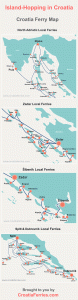
Large downloadable Croatian islands ferry map for planning your island-hopping trip to Croatia – We made a compilation of all islands map to present it as an island hopping planner for Croatia. Take this map with you if you are still not sure where to go and wish to explore further or decide once you arrive.
Bonus map:
X Large map of Croatian islands – this is a simple map which shows numerous Croatian islands, very good for initial orientation as well as further reference.
Ferry Schedules and Info
- Croatian Islands Ferries
- Ferry Timetables
- Ports
- Ferries from Italy to Croatia
- Ferries to / from Croatian Islands
- Ferries to / from Croatian Mainland
- Booking Ferries in Croatia
- Prices
- Ferry Companies
- News
- FAQ
- Tips and Guides
- Ferries Map
- Island Hopping
- Forum
- Ferry service status and weather forecast
- Ferry Photos
- Accommodation
- Car Hire
Connect with us


